Expiring the Internal Combustion Engine Car

The US state of Washington has decided to ban sales of new cars with internal combustion engines (ICE, gasoline or diesel) by the year 2030. That is five years earlier than in the state of California.

There are two issues to overcome for a switch to battery electric vehicles (BEVs): supply and charging. Two common worries however will not stand in the way of BEVs replacing ICEs: cost and range. Let me explain.

Battery cost per kWh has been dropping for decades and this trend is expected to continue. This is highly significant: Most parts of a BEV car other than the big battery cost either the same as in an ICE car or they’re cheaper. As a result, the cost of batteries will stop being a major obstacle to adoption of BEVs years before the end of the decade.

The same is true for range. Cheaper batteries mean BEVs with more capacity will become affordable. The higher the capacity, the more km of charge can be replenished in a given number of minutes. For example, a Nissan Leaf with a 40 kWH battery will fast-charge from 0 to 80% in 40 minutes. The Volkswagen ID.4 First Edition with an 82 kWh battery (of which 77 kWh are usable capacity) will go from 5% to 80% charge in 38 minutes, essentially double the charging speed (kWh added per minute) for a battery with twice the range. If you can add hundreds of km of range in the time it takes you to use the toilet and get a cup of coffee then BEVs will be just as viable for long distance trips as ICE cars.

By the middle of this decade there is likely to be a wealth of different battery electric vehicle models on the market, with even BEV laggards such as Toyota, Honda and Subaru having joined in. Production could increase to about 50% of new sales of several large makers (e.g. GM, VW). It will have to scale up further, with the necessary increase in battery production capacity, by the end of the decade to make this happen but it seems eminently doable. Right now, the major bottleneck to ramping up production is not lack of demand but limited availability of battery cells. Every big car maker getting into BEVs will have to build Gigafactories churning out battery packs, or team up with battery makers who make these huge investments.

The more BEV there will be on the road, the more the impact on the electric grid becomes an issue. If you have a car that can cover 300 km or more on a full battery and you can charge at home every night then most likely you will almost never have to seek out a charging station, unlike drivers of ICE cars who regularly will have to fill up at a gas station. BEVs parked in a driveway or garage with a nearby wall socket are much easier to accommodate than cars currently parking in the street or on parking lots, who will require capacity at paid public charging points, which are more likely to be used at daytime. The grid has plenty of capacity for off-peak charging (e.g. overnight), but if a lot of people want to do their charging at superchargers or other fast charging points, this could require an upgrade in generating and transmission capacity to cover a higher daytime peak load. Vehicle to grid technology would help to make this more manageable, as cars sitting idle in a driveway could provide spare power for the few cars doing the odd long distance trip.

In any case, I see a date roughly around 2030 as the Goldilocks target for a phase-out of ICE-powered new cars. For high income countries this goal is neither too unambitious nor too unrealistically aggressive. Japan’s goal by contrast for a phase-out by the mid-2030s that still allows hybrid ICEs like the Toyota Prius after that date is quite unambitious. By setting the bar that low, prime minister Suga pleases Toyota, as expected, allowing it to keep selling dated technology in Japan that they will no longer be able to sell elsewhere. That puts Japan in the company of developing countries, which will most likely continue using ICE cars exported from rich countries for years to come.

The sooner rich countries switch to BEVs, the shorter the long tail of CO2-emitting ICE cars still running in poorer countries will be.

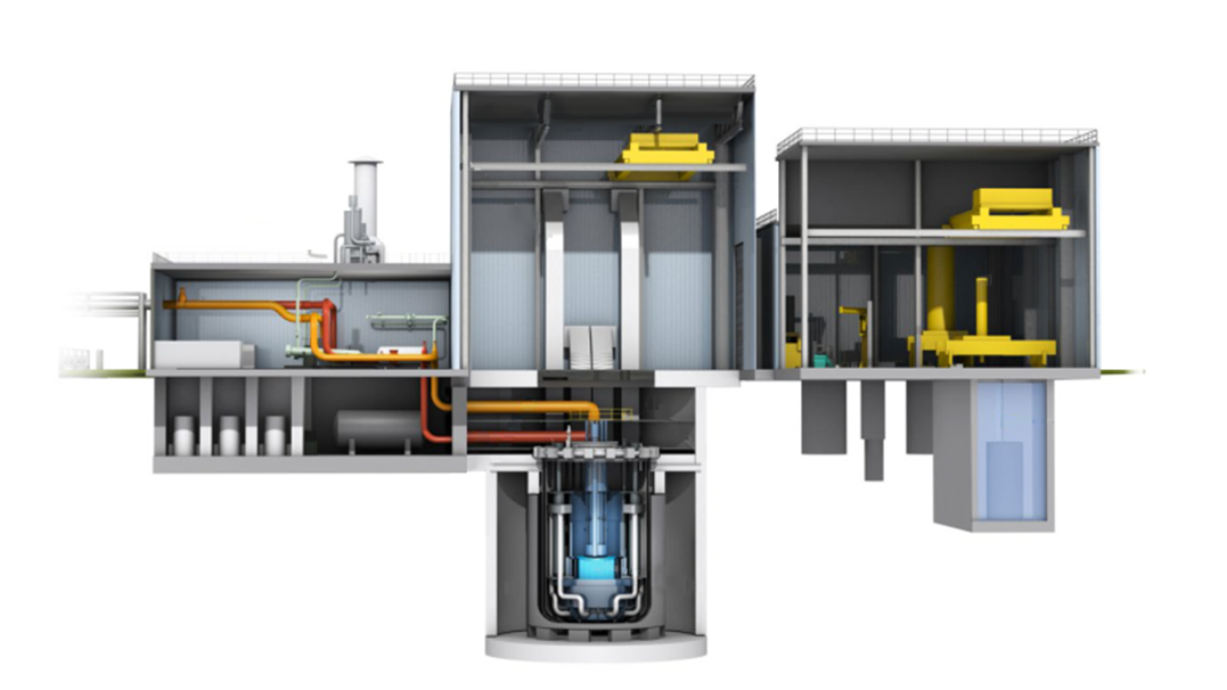
Releasing Tritium-tainted Water from Fukushima 1

The Japanese government has approved a plan by Tepco to release more than a million tons of water stored in tanks at the site of the Fukushima 1 nuclear power station. The water is supposed to be gradually released into the ocean starting two years from now.

Currently about 1.2 million t of contaminated water are stored on site, an amount that is increasing by about 170 t per day. Tepco is expected to run out of space at the end of 2022. Water is being injected into severely damaged reactors on the site to cool the remains of nuclear fuel left inside. It leaks back out, mingles with ground water that seeps in and is then purified through a filtration system called ALPS. This removes most of the radioactive contamination, but leaves tritium, a radioactive isotope of hydrogen which can not be chemically removed from water. So it ends up in the storage tanks.

Proponents of the release argue that tritium poses little hazard in small quantities. Radiation from tritium is so weak, it only travels for a couple of mm through air and it is stopped by the dead cells on the outside of human skin. Even if ingested it does not accumulate in the human body.

The water released will be diluted to levels so low it would meet drinking water standards in Japan and in other countries. Opponents fear an economic backlash against local fisheries or argue in principle that Japan has no right to contaminate the Pacific ocean, which is not just their territorial waters but shared by many other countries.

Proponents call such criticism hypocritical, given that many other countries, including the Republic of Korea, routinely release tritium into the ocean from their own nuclear facilities.

The issue is complicated. First of all, whether the danger from the water release is real or exaggerated, fishermen will suffer economically because consumers will end up avoiding fish from Fukushima more than they already do, even if it was safe to eat. If the release is unavoidable, the fishermen should receive compensation for their economic losses. That is only fair.

The truth about the water is not black or white. The 1.2 million t of water that has accumulated over the past decade was treated in different ways at different times. Some may indeed contain only those low levels of tritium as a contaminant, but other tanks will hold water that still has significant amounts of caesium, strontium and other dangerous isotopes that unlike tritium can accumulate in organisms and pose long term hazards. More purification and testing will definitely be needed before a release can take place. As Motoko Rich and Makiko Inoue reported for the New York Times in 2019:

Until last year, Tepco indicated that with the vast majority of the water, all but one type of radioactive material — tritium, an isotope of hydrogen that experts say poses a relatively low risk to human health — had been removed to levels deemed safe for discharge under Japanese government standards.

But last summer, the power company acknowledged that only about a fifth of the stored water had been effectively treated.

Last month, the Ministry of Economy, Trade and Industry briefed reporters and diplomats about the water stored in Fukushima. More than three-quarters of it, the ministry said, still contains radioactive material other than tritium — and at higher levels than the government considers safe for human health.

The authorities say that in the early years of processing the deluge of water flowing through the reactors, Tepco did not change filters in the decontamination system frequently enough. The company said it would re-treat the water to filter out the bulk of the nuclear particles, making it safe to release into the ocean.
(New York Times, 2019-12-23)

Long term there is no real alternative to releasing the water. Once its radioactivity has been reduced to only tritium, dilution and disposal at sea should pose little risk.

The challenge however is that Tepco and the government have a public trust problem, at home and abroad. How do we know the water released will be as clean as claimed?

Any release process needs to be transparent and independently verified to make sure there are no shortcuts or other shenanigans.

See also:

My team “Maillot 24Tokyo” ride of AR Nihonbashi Flèche 2021

I survived my second Flèche ride from Toyohashi in Aichi prefecture back to Tokyo (on Strava) and my third Flèche overall.


Although we officially did not finish again, I rode 401 km altogether from Saturday morning to Sunday afternoon, including the entire 368 km route as planned, just not within the set hours. A Flèche is a randonneuring event where teams of 3 to 5 machines (tandems only count once) ride at least 360 km in 24 hours towards a central location / meeting point. At least 25 km have to be covered after hour 22 of the 24 hour ride. It was organised by AR Nihonbashi.

We used almost the same course again as last year, only the part close to Tokyo was different. The biggest difference overall was that it didn’t rain all day on Saturday as it had last year. Therefore I rode the whole day in shorts instead of in rain gear and the temperature was much more pleasant too.

To get to the start, I drove to Aichi by car the day before (I can’t rinko my Elephant Bikes NFE). I was joined by my wife and my son. Together we visited Cape Irago (Iragomisaki) on the Atsumi peninsula of southern Aichi. After dropping me off they drove back to Tokyo. The peninsula is beautiful. I was impressed by the natural forests that are a sprinkle of different colors, unlike around Tokyo where much of the current forests are regrown mono-cultures planted after post war clearcutting.

I had dinner with two other team members, then went to bed at 21:00.

The alarm went off at 05:15 and we assembled at 06:00 to get the bikes ready.

It was a 20 minute ride to the official start at a 7-11 on the outskirts, where we set off at 07:00. We head a very pleasant tailwind on our ride through farm country out to Iragomisaki, where we uploaded a group picture in front of a road sign to prove passage.

The view from the road next to the Irako View Hotel (伊良湖ビューホテル) was breathtaking. You could see the coast of Mie prefecture on the other side of the entrance to Ise Bay and various islands in the sea. I took in the view but we didn’t stop for a picture. Here’s a picture from Wikipedia (By Bariston – Own work, CC BY-SA 4.0):

We headed into the headwind that would be blowing in our faces for the next 120 km. Sometimes we took turns leading the ride. Many of the farmhouses had a storehouse between it and the coastal side, probably to block the wind.

There were also many greenhouses. Regardless of shape and size, glass or plastic they all seemed to have fuel oil tanks with the JA logo (Japan Agricultural Cooperatives), so it’s a safe bet that JA sells most of the fuel oil consumed to help grow crops in the cold season. Lots of signs advertising melons which are currently out of season but we came across many kei trucks loaded with cabbages.

There were many wind turbines in Aichi and also Shizuoka, as well as many photovoltaic installations. Their ubiquity there highlighted for me how few of them we have in Tokyo and Kanagawa. Perhaps Chubu Power is easier to deal with for feed ins than Tepco is, especially for wind power.

At noon we stopped for lunch at a ramen and gyoza place about halfway between Cape Irago and Omaezaki.

As we passed the former Hamaoka nuclear power station (it is permanently shut down) we were passed by a group of three cyclists on mamachari. Actually, one was a hybrid bike with flat bars while the other two were bona-fide mamachari. It was team ”マチャリはロング向き!” (“Mamachari is suitable for long rides!”) running in the AR Nihonbashi event and they were steaming ahead of us.

We got to Omaezaki a little after 16:00. By then it was a Century ride (160.9 km / 100 mi), but not even half of what we had set out to do.

As the course turned north here, the headwind ceased and became more of a tailwind again. It got dark near Shizuoka City.

I had felt a bit sleepy after lunch but then felt OK again. Over the next couple of hours others became sleepy as we were riding through the dark and it became more and more of a problem.

I wasn’t able to see Mt Fuji on the drive on Tomei expressway on Friday because of low clouds and now I couldn’t see it because it was night time. After crossing Fuji city and Numazu we started our climb in Izu towards Atami toge. When we finally got to the top, we had to take another power nap break at the tunnel entrance. We put on all our extra clothes for the steep descent down to Atami (13 percent). After that my rear disk brake, which recently had been very noisy and not very effective (maybe due to oil contamination from the chain) has been working perfectly again, as the heat and wear effectively decontaminated it.

Dawn approached as we headed from Atami to Yugawara and Manazuru.

We had burnt up most of our time buffer for the sleep break planned at the 22 hour stop by then, but the sleepiness in the team only got worse. So after another long break at Manazuru we sent in our DNF-notification to the event organiser. We headed to Odawara and had breakfast at the station.

After that, my friends rinko’ed their bikes for the train home while I continued on the planned route to Yamato, then another 26 km to my home. I also needed a few naps to get me home safely.

With this ride, I now have 104 contiguous months of Century a Month.

I may join a 400 km brevet later this spring and a 200 km brevet or two again after the summer.

As for the Flèche that we DNF’ed twice now, let’s see what we can come up with next year. We may just try it again a third time 🙂

Pacific Quake Risk Report and Nankai Trough

A report by the Earthquake Research Committee of the Japanese government released on 26 March 2021 puts the probability of a magnitude 8-9 quake along the Nankai Trough off the coast of central Japan at 70 to 80 percent:

The results stem from high probabilities of two huge offshore quakes over the next 30 years.

One is a temblor with a magnitude of around 8 forecast to occur with an 80% probability along the Chishima Trench off Nemuro, Hokkaido.

The other one, seen occurring along the Nankai Trough off the country’s central to southwestern coast with a magnitude of 8 to 9, has a probability of 70% to 80%.

As an investigative report by Keiichi Ozawa in the Chunichi Shimbun exposed last year, this figure is based on manipulation. The estimate for the Nankai Trough uses a different methodology from the one used for all other areas of Japan. If the same methodology were used, the estimated probability would be slashed to about 20 percent.

When a government panel of earthquake prediction experts revised the probability of the Nankai Trough earthquake scenario from “about 70 percent” to “between 70 and 80 percent” in February 2018, some pointed out that the figure was inflated. The minutes of previous meetings in 2012 and 2013, obtained by the Chunichi Shimbun, revealed the figure had been slammed as “unscientific” at the time.

The seismologists were of the opinion that the probability was not being presented fairly and called for the release of not only the highest figure but a low one as well.

But their argument was swiftly shot down by scholars in the field of disaster prevention, who, the minutes of the preliminary meetings showed, made no secret of their desire to prioritize securing themselves budgets over respecting science.
(…)
During joint sessions the committee held in December 2012 and February 2013, seismologists and disaster prevention experts clashed over whether to mention the low figure for the Nankai scenario in the “main text,” or summary, of the government report.

In the draft version, there was no mention of the fact that the time-predictable model — the measurement of land movements from previous quakes taken at Murotsu Port, northwest of Cape Muroto in Kochi Prefecture — was applicable only to the Nankai scenario, and that applying the model used for all other earthquakes would slash the probability to about 20 percent.
((Japan Times, 2020-07-10)

I am wondering how long these questionable figures will remain unchallenged year after year.

Rescuing DVD-RAM Recordings from Obsolescence

I bought my first video camera more than 30 years ago. I went for Hi8, a higher resolution version of Video8, as opposed to VHS or VHS-C which was also popular at the time. Since then I have switched device and formats several times. There was always the worry that I would lose access to my recordings as devices able to read the old media become obsolete or die or the recording media themselves fail from old age. Losing irreplaceable videos of our kids when they were little is something I really didn’t want to experience. Here is a short summary of how I have been dealing with these challenges.

Hi8 (PAL) – early 1990s
I bough my first camcorder when I still lived in Germany so naturally it used the PAL standard (625 scan lines, 50 Hz). I did a lot of analog video editing using an S-VHS VCR, which could interface to the camcorder using S-Video cables. Even after I moved to Japan which uses the NTSC standard (525 scan lines, 60 Hz) I kept recording in PAL. A Samsung multi-standard recorder allowed me to record from the camcorder to NTSC VHS tapes. I also bought a multi-standard analog TV that could display PAL, SECAM and NTSC. However, for many years I just collected the Hi8 PAL master tapes in a cardboard box.
Along came Digital8, a successor to Hi8 that as the name indicates used digital recording but was backwards compatible with Hi8 and could play the old tapes. So eventually, as Hi8 camcorders were already becoming obsolete, I bought a second hand one off eBay when I was visiting Germany. It had an IEEE 1394 (Fireware) connector that made it possible to copy digital video to a computer equipped with that interface. I experimented with PCs with plug-in IEEE 1394 cards, but ultimately it was a Mac mini that allowed me to copy the old Hi8 PAL tapes to a hard disc using the German Digital8 camcorder, a Firewire cable and iMovie which was bundled with macOS. The output files were “.dv” files. Some tapes were difficult to load and took many tries before the camcorder would even play them, but I was largely successful.

Hi8 (NTSC) – late 1990s
When my kids started going to kindergarten I finally switched to a Japanese camcorder, still a Hi8 model but for the NTSC standard (US/Japan). Like with the PAL camcorder I saved all the tapes in a box. The Samsung multi-standard VCR developed issues and we bought a new S-VHS VCR equipped with a DVD drive. It supported DVD-R, DVD-RW and DVD-RAM, the latter with caddies (cartridges). It also supported S-Video. It was relatively easy to use the S-Video interface to copy from the Hi8 (NTSC) camcorder to double sided DVD-RAM media. About 2 hours of video would become one 4.2 GB file on DVD-RAM. I chose DVD RAM because it supposedly was more robust than DVD-RW (especially with the protective case), but as Blu-ray came along DVD-RAM became less and less common, with many DVD multi drives not supporting it any more. In 2008 and 2010 I made a stack of 6 double sided DVD RAM media that held video from 21 Hi8 NTSC tapes, but when the DVD section of the VCR died, I no longer had anywhere to play them.
This year I finally bought a USB 3.1 DVD drive that also supports DVD-RAM, though without support for caddies. I went for the BUFFALO DVSM-PTV8U3-BK/N (2180 yen, about US$21). It worked very well once I removed the DVD-RAM disks from their protective caddy. I hooked it up to a Windows 10 machine, plugging the two USB cables into different USB ports (USB 2.0 for power, USB 3.1 for data). I copied the entire folder structure on each side of the media to a separate new folder on the server hard disk. The actual video information on a DVD RAM disk is in a file called VR_MOVIE.VRO which is found inside a folder called DVD_RTAV. The open source VLC player will play this .vro file, as well as the .dv file captured on the Mac mini from the Hi8 recorder.

MPEG (NTSC) hard disc recorder – 2000s
After the various Hi8 recorders I moved from tape to a hard disk based camcorder, a Toshiba Gigashot GSC-R30. This used a Toshiba-made 1.8″ notebook hard disk. It also had a USB 2.0 interface and could be connected to any PC. The MPEG files would play on any MPEG player with support for its audio codec, including VLC. Therefore backing up and preserving these videos was pretty painless.

Smartphones – 2010s and beyond
The Toshiba GSC-R30 was the last camcorder I ever bought. Occasionally I still shot video on my Nikon D3300 DSLR camera, but mostly I moved on to mobile phones which may not have had an optical zoom or as much recording capacity, but they were always in your pocket and so easy to use and the quality improved with each generation.

Don’t lose your media!
If you value the images and videos you recorded over the years, make sure to migrate them to recording media that you can access for years to come and keep doing that. Also make sure you have backups. Tapes, DVDs, hard disks and SSDs will all become unreadable at some point. Don’t keep irreplaceable files on one laptop and hope that it will work forever because it won’t. At the very least, buy a USB drive and make a backup copy. Even better, buy another USB drive, make another backup copy and give it to someone else in your family. It’s better to have your valuable data saved in more than one place.
I am a great fan of the VideoLAN VLC media player. You can throw just about any video or audio format at it and it will be able to play it. I highly recommend it! 🙂

Navalny tells the truth about Putin

If agents working for Vladimir Putin had succeeded last August when they tried to murder Alexei Navalny with a cold war era chemical agent, it would have made him only the last of many Putin critics who lost their lives since this crook took power in Russia. Anna Politkovskaya, Boris Nemtsov, Alexander Litvinenko and many others died without their killers or the people behind their deaths ever being brought to justice.

Navalny was lucky to survive because his plane made an emergency landing, he got emergency treatment quickly and was then transported to Germany where he recovered. His courage to return to Russia, despite facing certain arrest, is simply incredible. He is a true hero.

Now Putin, who doesn’t dare mention Navalny’s name in public, has a problem. Too many eyes are on Navalny’s fate now. If he gets killed, there will be retribution. But if he doesn’t get silenced, his courage will inspire others to no longer put up with the theft, lies and oppression.

I watched the powerful two hour documentary that Navalny and his Anti-Corruption Foundation prepared and which was made public after his arrest. It is already on course for more than 100 million views on YouTube. I expect Putin’s Russia will never be the same again. He has finally been exposed for who he really is. I hope the courageous protests of countless brave Russians and pressure from abroad will deter Putin’s regime from murdering Navalny this time.

Putin’s Russia is a prototype for authoritarian regimes in a number of countries that use nationalism as a cover for crooks and their families and friends looting the country. When Putin finally loses power, it will be a game changer for the struggle for democracy, human rights and justice worldwide.

Parler is Back on New Web Host

Parler, the web forum popular with Trump supporters and far-right groups, is back online after losing its web hosting when AWS kicked them off for violating their terms of service. After the violent insurrection on January 6 in which 5 people died, AWS had confronted Parler with a a list of 98 examples of messages that “clearly encourage and incite violence.” Posters had threatened politicians with firing squads and encouraged protesters to bring weapons to the presidential inauguration on January 20, 2021.

“We need to start systematically assassinating #liberal leaders,” read one post. In another now-deleted message posted the day after the attack, pro-Trump lawyer Lin Wood called for Vice President Mike Pence’s execution, writing “Get the firing squads ready, Pence goes FIRST.”

“These are things that mainstream social networks have policies against,” said Kevin Roose, a tech columnist for The New York Times. “And so, if you got kicked off Twitter for saying them, a lot of the time your next step was to make a Parler account and just move your followers over there.”
(CBS, 2021-01-11)

When Parler did not remove all of the violent messages they had been notified about, AWS terminated the hosting. Since then Parler scrambled to find a replacement.

As has been reported, Parler had first moved to Epik as their new registrar, as can be seen in their WHOIS record:

Domain Name: PARLER.COM
Registry Domain ID: 1336588_DOMAIN_COM-VRSN
Registrar WHOIS Server: whois.epik.com
Registrar URL: http://www.epik.com
Updated Date: 2021-01-11T19:28:03Z
Creation Date: 1998-05-28T04:00:00Z
Registrar Registration Expiration Date: 2022-05-27T04:00:00Z
Registrar: Epik, Inc.
Registrar IANA ID: 617
Registrar Abuse Contact Email: abuse@epik.com
Registrar Abuse Contact Phone: +1.4253668810
Reseller:
Domain Status: clientTransferProhibited https://icann.org/epp#clientTransferProhibited
Registry Registrant ID:
Registrant Name: Privacy Administrator
Registrant Organization: Anonymize, Inc.
Registrant Street: 704 228th Ave NE
Registrant City: Sammamish
Registrant State/Province: WA
Registrant Postal Code: 98074
Registrant Country: US
Registrant Phone: +1.4252025160
Registrant Phone Ext:
Registrant Fax:
Registrant Fax Ext:
Registrant Email: 20373@anonymize.com

Now they’re back with a single page placeholder site while the forum itself is still unavailable. The website currently resolves to IP address 190.115.31.151, which is in the following network registered in Belize but with a Russian phone number:

inetnum: 190.115.16.0/20
status: allocated
aut-num: AS262254
owner: DDOS-GUARD CORP.
ownerid: BZ-DALT-LACNIC
responsible: Evgeniy Marchenko
address: 1/2Miles Northern Highway, –, —
address: — – Belize – BZ
country: BZ
phone: +7 928 2797045

According to that company’s LinkedIn profile they’re based in Rostov-on-Don. This Russian company is a major provider of protection against Denial-of-Service attacks. In other words, they filter web traffic for websites hosted behind the filter. Most likely the actual hosting is at a different company to which DDOS Guard Corp. forwards the filtered traffic.

Parler’s troubles go deeper than finding hosting. Without access to Google’s Play Store for Android or Apple’s App Store, even with new hosting mobile users will only be able to access the site from a browser. The company also lost access to its SMS provider and other services, all of which will make it an uphill struggle to make a comeback. Most likely, other sites and services will absorb some of the user base while the forum is gone.

As the domestic terrorists who invaded Congress on January 6 will get prosecuted, that will also cast a spotlight on what went on at Parler in the weeks and months before the violence took place. Freedom of speech does not extend to inciting people to murder.

See also:

Germany Reaches Renewable Energy Milestone

The drop in demand for electric power due to the Covid-19 pandemic helped Germany reach an environmental milestone in 2020: For the first time more electricity from renewable sources was fed into the German grid than from fossil fuels and nuclear combined.

50.5 percent of the net electricity production came from wind, solar, hydro and biomass vs. 49.5 percent from fossil or nuclear. Wind power alone accounted for 27 percent of all electricity, more than brown coal and hard coal combined (24.1 percent).

2020 numbers for Japan are not yet available, but in 2017 renewables excluding hydro power accounted for only 8.1 percent of the Japanese electricity production, with hydro providing another 7.9 percent. 39.5 percent came from LNG, 32.7 percent from coal 8.7 percent from oil and 3.1 percent from nuclear.

Japan’s power generation plan for FY2030 foresees only 1.7 percent for wind power, 7 percent for solar and an overall share for renewables (including hydro power) of 22-24 percent of the total. That is less than half the share that Germany achieved in 2020, a whole decade before Japan.

One Hundred Months of Centuries

One hundred consecutive months of at least one Century (i.e. a bike ride of 160.9+ km) a month complete! I started doing long distance bike rides in March 2012 and from September of that year started doing at least one Century per calendar month.

This latest ride in Izu covered 172.5 km (on Strava) and also added 24 VeloViewer tiles.

A ride in west Izu in December is almost like a personal tradition for me. As the weather turns drier in the winter there are so many nice Fuji views to be had and you can ride around the entire peninsula without climbing a single hill higher than 300 m.

Well, that’s the theory. But it actually rained for the first two hours and the return route through the center of the peninsula that I took to get back to Mishima had a climb to 650 m elevation and only 7 C in the dark. I had about 1,000 m of elevation gain on the way down to near Iwachi Onsen (south of Matsuzaki), but another 1,200 by replacing the hilly coastal road that I had come on with Rt15 and Amagi toge/Rt414 on the way back.

We met up at 8:00 at Mishima station. It had been raining on my drive on Tomei from Tokyo, but seemed to almost have stopped by the time we set off, so I left my rain gear in the small backpack I was wearing. The rain picked up again, bringing back memories of my rainy Fleche ride from Aizu to Tokyo in mid-October. Our first stop was at a 7-11 on the Izu north coast, before we headed out to the NW corner.

The Honshu coast was completely obscured by rain clouds, no views of Mt Fuji. However, gradually the sky brightened and the rain stopped. We bought some mikan from an unattended roadside stall (9 mikan for 300 yen) which we shared at a viewpoint overlooking Ida village.

First we could make out the side of the mountain, with snow visible at the top of the visible portion, just below the clouds. In Heda we visited the sandspit with the shrine. In clear weather you can view Mt Fuji behind the entrance to the local bay with the tori of the shrine in the woods on the sandspit from a small pier the locals use for fishing. The water there is crystal clear.

Then we climbed the biggest hill on the way to Toi, where we had Chinese lunch (because it was quick and December daylight is short). After that Jochem headed over the mountains to the center of the peninsula to catch a train back while Colin and I continued to Matsuzaki as fast as I could.

The rain had washed off all the chain lube and it was squeaking. I had to re-lube from my little container, which fixed it.

From Matsuzaki, Colin headed inland on Rt15 to get to Shimoda while I continued towards Iwachi onsen / Kumomi onsen. On a hill overlooking the Matsuzaki coast I took pictures when three Japanese road cyclists came up. We started to chat. In the end it turned out one lived in my neighbourhood (within half a km) and I had met with one of the others at a Half-Fast meeting a couple of years ago! The world is such a small place 🙂

Since I was running out of daylight, I headed back north and took the same route Colin had taken. From north of Shimoda I headed towards Amagi toge. My feet were wet the whole day from the rain, even though I had bought a simple pair of socks at a convenience store to change, because the shoes were still wet. My fleece trousers were also moist from not wearing the rain pants in the morning. So I wasn’t very comfortable, despite wearing the rain jacket as an extra layer. Dry feet are crucial for comfort and I resolved I will finally do something about keeping my shoes dry in the rain.

In one place the road passes a corkscrew-like ramp. The whole climb is very steady, mostly 5-7%, so not difficult but just long. It’s about as much climbing as Yabitsu pass, but less steep. The road is kind of remote, with no houses around and I could hear many deer whistling in the forest, but cars were passing quite regularly. North of the tunnel at the top of Amagi pass it was a loooong descent (more than 20 km of coasting). Once that leveled off I could follow the river and main roads back to Mishima, with no significant climbs.

I got back home around 01:00 in the morning, showered and went to bed. It felt good to have done the big ride for the month and extended the streak into the triple digits, which was my aim for the whole year.

Izu is always well worth a visit.

I don’t know how many more Centuries I’ll manage in December but I plan to continue in January 🙂

My team “Maillot 24Tokyo” ride of AR Nihonbashi Flèche 2020

The Fleche Nihonbashi 2020 (フレッシュ日本橋2020) will remain my longest ride of the year, I am sure. I rode 403 km from the hotel in Aichi where we set off on Saturday at 06:30 to my home in Tokyo on Sunday (on Strava). During that time I slept 3 1/2 hours and experienced 18 hours of rain.

In a Fleche, teams of 3-5 bicycles have 24 hours to ride a distance of at least 360 km towards a central meeting point. I had successfully participated in a Fleche in 2019. Two members of the 5 person team this year were different from last year. Like last year, only 4 of them actually rode.

Our event team name was “Maillot 24 Tokyo”, a pun on the fact that we were going to ride 24 hours (“ni shi”) to Tokyo in our new AJ NishiTokyo jerseys. The 2020 run was originally scheduled for April but due to Covid-19 it got pushed to October 17-18. Because virtually no randonneuring events have taken place from April to September, many randonneurs’ fitness has suffered and DNS (“did not start”) is more common than usual.

I had been watching the weather forecast closely. Our start was in Toyohashi, Aichi prefecture and the planned goal in Totsuka, Kanagawa. Normally, the prevailing wind conditions would give you something of a tailwind along this relatively flat course. We had only about 1000 m of elevation gain in the first 2/3 (240 km) of the ride. However, as the date of the ride came closer the forecast became rainier by the day. Ultimately it rained on Saturday from before the start to when we decided to officially DNF (did not finish) in Okitsu, Shizuoka after midnight. The north-easterly headwind that we had for most of Saturday more than made up for the relatively flat course. That and three punctures by one team member meant we could not finish within the time limit. We did finish the ride on Sunday after just a few hours of sleep at a Kenkoland hotel and public bath, riding back to Kanagawa and Tokyo together.

I made my way to Toyohashi by car on Friday. Everybody else took the shinkansen. I drove to Lake Hamana (Hamanako) halfway between Hamamatsu and Toyohashi. There I unloaded the bike after which my wife and daughter headed back in our car for a separate adventure. After 26 km I arrived at the hotel a little after noon. Since I couldn’t get into my room until 15:00 I first had lunch at a convenience store on us tax payers (1000 yen Go To Travel coupon) and then explored the city by bike. Toyohashi has a castle museum, which is free to visit, in what is now the city park (formerly the castle grounds). After I checked into my room the other participants arrived, minus one who chose to DNS due to the weather forecast. What a sensible person! 🙂

While preparing the bike in the morning I decided that I was going to be too warm in my full rain gear, even with 11 C. I wore my rain jacket on top of my base layer and team jersey, but not the rain trousers — just my regular uniqlo shorts (65% / 35% polyester / cotton). Only on the last convenience store stop before sunset did I finally put on the rain trousers, as well as a windbreaker under the rain jacket. That was perfect temperature-wise.

The weather was very gloomy all day, with a steady drizzle and wind. There were no other cyclists around as we headed out 45 km to Cape Irago, the westernmost point of our ride. 7 km later we did our first convenience store stop for a 15 minute break. Then we headed east along the coastal road. After about 105 km we stopped for lunch (ramen and gyoza). It was only 11 C for most of the morning. I think the warmest we saw was 16 C around Shizuoka-shi.

These are two of the 5 bridges running side by side on the southern end of Lake Hamana, where it drains towards the Pacific.

Hamamatsu in Shizuoka is home to both Kawai and Yamaha pianos. You can actually tour the factories by appointment (or at least you could before Covid, not that we would have had time for that). Both Aichi and Shizuoka have a lot of Japanese-Brazilian immigrant workers, so Portuguese tends to be a common second language on signage, like Russian in parts of Hokkaido and English in the rest of Japan:

The Hamaoka Nuclear Power Station in Shizuoka is one of the most tsunami-exposed plants in Japan and mostly upwind from Tokyo. It sits directly above a fault line where two tectonic plates meet in a subduction zone (the most dangerous type of fault line – 9 of 10 of the biggest earthquakes in the last 100 years happened at subduction zones). All 5 units at Hamaoka were shut down in 2011 and a planned sixth unit was cancelled.

After 166 km we passed Omaezaki, another cape. The Shizuoka coastline turns north there. From there we were heading up Suruga bay, with the west coast of Izu across the sea. You could have admired the west Izu coast and Mt Fuji if the weather had been good, which of course it wasn’t. 2 km after we took checkpoint pictures at the cape we stopped at another convenience store. I completed my rain wear and thermal layering as it would soon get dark.

At one point we lost two riders at the back and turned around to find them fixing a front wheel puncture in the dark. Later in the ride the same bike punctured at the rear wheel, twice. Eventually we used up all 700C spare tubes we had (two of us ride 650B and rely strictly on our own tubes).

By then it was getting clear that we could not stick to the time plan and that we wouldn’t make it in time. The headwind and rain were too much of an obstacle to that and the punctures didn’t help. We stopped for dinner at a Cocos restaurant. Our ride leader suggested taking a break for the night at Kenkoland Suruga in Okitsu, where he had rested at brevets before. I was very reluctant to do that as it would effectively have cut my biggest ride of the year in two. For me, technically one ride ends once I sleep in a bed. Ultimately I am very glad though that I finally went along with the change of plan. I would have missed the best part, even if that 403 km ride sort of is two rides now.

Close to 1:00 we parked our bikes in the car park of the Kenkoland. Fortunately rooms were still available and Go To Travel discounted the room rate with breakfast. I set the alarm for 05:30 and was out like a match after my head touched the pillow. When I looked out of the window in the morning the rain had stopped. On the very left I could make out one side of Mt Fuji with fresh snow on top, then many smokestacks of chemical plants near Fuji City, with the Izu coastline to the right. I was very happy about the change in weather. Breakfast started at 06:00 and we were out and on the road again around 07:00.

Within minutes we got great views of Mt Fuji. Our course joined the Old Tokaido road, on which people had travelled on foot between Kyoto and Edo back in the old days.

About 260 km from the start we crossed the bridge over the Fuji river, which is a big turning point in the 300 and 400 km brevet courses of AJ NishiTokyo. Here the ride joined up with rides from Tokyo that I had done before. It’s crazy when you feel like you’re almost home but actually still have to cycle another 140 km! 🙂 Somewhere on the way to Numazu we switched from the road to a bicycle path on top of the tsunami barrier at the beach, which continued for many km. The views from there were fantastic and we took time for pictures, now that we didn’t have an arrival time to beat.

After Numazu and Mishima the road climbed into the mountains south of Hakone to Atami pass. I had crossed Izu only at Hakone or further south between Shuzenji and Ito. More Fuji views in the mountains. On about 10 km we did one fifth of the total climbing of the 400+ km ride. We passed the MOA, an art museum near Atami. The descent to Atami was very steep and treacherous (one minor crash but the rider could continue). I was glad I had disk brakes and wide tires for traction.

Once we got closer to Odawara,traffic got quite bad, as it usually does on a Sunday there, especially as this was a day with decent weather immediately after a rainy day.

As we had officially called in our DNF already, we were all free to go any way that would work for us. The ride leader and another member headed to Odawara station to have a meal together before using their rinko bags for the train ride home. Another member and and I cycled back another 73 km to Tokyo via Rt135 and then Rt246 which again was very busy. But we got home safely about 36 hours after we had started.

A few things I took home from this ride:

Preparation for an event like that is really important. I had all the clothes I needed, all the cables and other electronic gear, no issues whatsoever and I also didn’t really carry anything bulky or heavy that was unneeded on this ride. Recent rides in cooler and partially wet weather had helped me figure what clothes to bring.

Physically I was well prepared due to my recent long rides. It was my 10th ride of 150+ km since the beginning of August. One of them was another brevet (i.e. with time limits), others were rides with faster friends (Thanks, Peter!).

I was very happy with the new GPS. The Wahoo Elemnt Bolt performed flawlessly. I rode the last 160 km without recharging, but on Saturday I could also charge it on the handlebar in the rain without issues. I loved the way it announced turns from the RWGPS cue sheet. The maps on the unit aren’t great but workable until you zoom out too far.

Sleep planning also worked well. I got sufficient sleep the week before. The day before the ride I got up early, which made it easy to go to bed early and fall asleep easily the night before the ride. The short night at the Kenkoland worked out pretty well too.

Two major changes I would make:

I need mud flaps for the mudguards to keep spray off the shoes, especially going through puddles on the road. That would also prevent lubrication issues on the chain. I had to relube with donated chain lubricant on the second morning (I had some in the bottom of the bag but my friends saved me from having to search for it) as the splashing water had washed off too much oil.

And I want some shoe covers for the rain, to definitely make sure my socks will stay dry when it’s wet out there. I had brought a second pair of dry socks which I used on day 2, but I could have done better with proper shoe covers.

I am glad I didn’t stubbornly continue the ride on my own without a hotel stop in the early hours of Sunday. Day Two was much more enjoyable with my friends and safer too.

I would join another Fleche ride in a heart beat. With a good team it’s one of the most enjoyable formats of randonneuring.

See also: