About Joe Wein

Software developer and anti-spam activist

Google privacy and account cancellations

After Google announced its new privacy policy to take in effect on March 1, 2012, some people announced their intention to cancel their Google accounts. In a Washington Post online poll almost 2/3 of readers said they would cancel their accounts due to privacy changes. My answer to that is: Oh, really?

Despite what the self-selecting samples of voters on that straw poll suggests, I doubt we’ll hardly see any significant response to the new policy. It won’t even be a blip on Google’s radar screen. I think it is safe to bet that most users of the Google+ service also have Facebook accounts, whether they use them much or not. Facebook and its history of data privacy (or lack thereof) is not exactly a benign alternative to anything Google offers. I can not see people stop using Youtube, cut themselves off from their Gmail accounts and switching to what, Yahoo or Bing for web searches? The fact remains, Google may not live up to its “do no evil” credo at all times or forever, but most of us have even less confidence in companies like Facebook or Microsoft.

Google’s move is all about more clicks, i.e. more advertising revenue, which is their life blood. If they can show better targeted ads on web searches based on what you write about in Gmail or watch on Youtube, that’s more clicks that their advertisers pay for.

What worries me is if their data gets opened to the NSA, police, etc especially under the loose rules of something like the Patriot’s Act. Inside the US the constitution has been eroded further and further over the years, while its protections have never applied to most fellow humans who do not happen to be US citizens, as far as the US government is concerned. That is not a problem specific to Google latest move though. It’s something that ultimately only US voters can solve.

Mount Daibosatsu (大菩薩岳) in January

Last weekend I did my first real winter hike, up Mount Daibosatsu (2057 m) near Enzan in Yamanashi prefecture, Japan.

Last year I did two hikes on Daibosatsu with friends, but on Sunday we went back for a mid-winter hike in the snow. It’s a longish train ride from Tokyo to Enzan, where we caught a 30 minute bus ride to the foot of the mountain. In winter many of the mountain roads may be closed due to snow, so we had to hike two hours just to get to a hut which in autumn served as a bus stop for our hike then.

Because it had been raining or snowing for two days, I was wearing rain gear on top of several layers instead of the usual trousers and winter jackets. I bought a pair of crampons (Evernew EBY015 L, 6 pin, L size) as recommended by a friend, which worked really well on the snowed in mountain. There were about 30 cm of snow in the higher regions.

We left Tokyo by Odakyu line before 05:00 and got off the bus near the mountain around 08:00. After about half an hour on roads above the village we put on the crampons for the snowed in trails and forest roads. Around noon we got to the ridge (Daibosatsu-toge, 大菩薩峠) and had lunch, then headed on through the deep snow to the top to enjoy the view and take pictures. Tellingly, the only other hiker we encountered up there was wearing snow shoes. With everything covered in snow and no other sounds except for some wind, the echoes from the mountains were amazing.

Mount Daibosatsu was one of my favourite hikes last year because of its views, but this last hike was very special. Fog was sitting in many of the lower valleys all around us while all the trees were covered in thick white snow that everything had a January calendar picture feel to it, but the best was Mt Fuji. I told my friends, I would have hiked the whole 18 km for the views of Mt Fuji alone. Somehow it seemed bigger or closer than ever and the light that surrounded it was magical.

Descending was much easier than climbing, as the snow acted as a friction brake. We descended in 2 1/2 hours versus 4 hours for the climb. We enjoyed food and drinks at a restaurant at the bus stop in the company of two other hikers. I am sure this won’t have been my last hike to Mt Daibosatsu.

(All pictures taken with Canon PowerShot S95)

Fukushima “cold shutdown” announcement up to 25 years too soon

The Japanese government has announced that the wrecked Fukushima Daiichi power station has reached a “cold shutdown”. The BBC quotes Prime Minister Noda:

“The nuclear reactors have reached a state of cold shutdown and therefore we can now confirm that we have come to the end of the accident phase of the actual reactors.”

It is meaningless to still use the term “cold shutdown” for a reactor in which the fuel rods and containment vessel have lost their integrity. It’s like saying the bleeding has been stopped in an injured patient who had actually bled to death.

The normal definition of “cold shutdown” is when, after the chain reaction has been stopped, decay heat inside the fuel rods has been reduced enough that the cooling water temperature finally drops below 100 C. This means the cooling water no longer boils at atmospheric pressure, making it possible to open the pressure vessel cap and remove the fuel rods from the reactor core into the spent fuel pool. After that the reactor core no longer needs to be cooled.

Only units 4, 5 and 6 have reached a genuine cold shutdown. Unit 4 had been shut down for repairs in 2010 and did not contain any fuel at the time of the accident. In units 5 and 6 a single emergency diesel survived the tsunami and prevented a meltdown there.

In units 1, 2 and 3 of Fukushima Daiichi the fuel melted, dropped to the bottom of the reactor pressure vessel and penetrated it. The melted rods then dripped down onto the concrete floor of the containment vessel and are assumed to have partly melted into the concrete up to an unknown depth.

While in a regular cold shutdown fuel can be unloaded within weeks, the Japanese government estimates it may take as much as 25 years before all fuel will have been removed. The technology to remove fuel in the state it’s in now does not even exist yet and will have to be developed from scratch. Even the most optimistic schedule puts it at 5 years, during which time the reactors will have to be cooled 24 hours a day, with no new earthquakes damaging them or knocking out cooling again, no major corrosion problems, no clogged water pipes, etc.

In my opinion, the announcement of a “cold shutdown” at Fukushima Daiichi is greatly exaggerated and was made mainly for political purposes. More than anything, it is meant to provide political cover for restarting other idled nuclear power stations during the coming year.

Converting driver’s licenses in Japan

It was reported today that US actor Dante Carver, best known for his role as “oniisan” (elder brother) in popular Softbank Mobile commercials, has been reported to prosecutors in Tokyo for driving without a valid driver’s license. The 34-year old actor from New York reportedly was stopped for a traffic violation in July of this year and showed the police an International driver’s license (IDL), which was technically invalid as he is a resident of Japan. IDLs are only valid in Japan if you come here as a visitor, not if you live here. If you hold a Japanese Alien Registration card, as is required for any foreign national staying longer than 90 days, that applies to you.

Even though Mr Carver broke the law, I have some sympathy for him, because the law is anything but fair on this. Drivers from many countries can obtain a Japanese license if they have held a driver’s license for at least three months before moving to Japan, without having to take expensive driving lessons and a test as any fresh learner in Japan. However, this does not apply to drivers from the US. They do have to take a practical test in Japan again after already having passed a test in their home state. Americans are by far the most numerous nationality amongst Westerners living in Japan.

When I first arrived in Japan back in the 1990s, I was told by other foreigners that UK driver’s licenses could be converted without a test, but German licenses could not. Later I heard that this had changed and applied for a Japanese license, which was granted. I had to answer questions about how many driving lessons I had taken before the German test. They were particularly concerned about how long I had held the license in Germany before first coming to Japan. I needed to document at what date the license was issued, when I had visited Japan and when I had moved here. I even brought all my old, voided passports with entry and exit stamps for backup. It took two trips to the driver’s license centre to get it done. I can’t tell you how relieved I was to have it finally sorted out.

By contrast, when I moved to the UK, I simply mailed off my German license to some office in Swansea and received the UK equivalent by mail. It was equally easy to swap the UK permit back to a German one when I returned to Germany a few years later.

Others are not as lucky as Brits and Germans and do have to take the test. It seems ironic that people are allowed to drive in Japan on IDLs while they’re unfamiliar with Japanese roads, but after they’ve been here for a while and have more experience they’re no longer allowed to do that and are forced to retake a test.

Now you might think passing this test should be trivial for any experienced, safe driver. I would not bet on it, as a Japanese friend of mine found out to her cost. Japanese driver’s licenses have to be renewed every couple of years within a month of your birthday. When she moved to a different address in the same town she forgot to have her driver’s license updated with the new address. Consequently the post card to remind her of the upcoming renewal never reached her. Like most Japanese she mostly used her health insurance card for ID.

When she next looked at her license, she noticed the renewal date was more than 6 months in the past. She contacted the administration and was told the license she had held for more than a decade had irrevocably expired. It was like she had never passed the test. She would have to take a new test from scratch. Including driving lessons, this easily comes to 300,000 yen or more.

The tests are not what you would expect. For example, before you get into the car you must bend down and look underneath the car for rocks, cats, booby traps or whatever, otherwise you have already failed it. That’s just the start. Everything is totally exaggerated (not unlike Japanese manga or TV dramas, I might say 😉 ). The tester would not give you directions such as “turn right at the next traffic light, then left at the intersection” as you go. Instead they would show you a map, tell you where you are and then ask you to drive them to a particular point. You’re supposed to memorize the route. It’s like they tested would-be taxi drivers! Of course you’re not allowed to look at the map again while you’re in motion. You can not pull into private property to make u-turns or to check the map if you get lost. Basically, the way to pass the test is to take many paid driving lessons around the same streets where the test will be conducted to thoroughly memorize the area.

It all has very little to do with road safety: Apparently the driver’s license administration and the tests are mostly staffed by former police officers in Japan. They retire from the police service before the age of 65 when they receive their full pension, serving in these other jobs for a couple of years. The more inflated the bureaucracy surrounding driver’s licenses, the more jobs for semi-retired police officers there are. Make it too easy to convert foreign driver’s licenses into Japanese licenses and some of these jobs might go.

GPS-logging my bike rides

Five weeks ago I started logging my road bike rides, runs and mountain hikes using the GPS in my Google Nexus S Android phone. I use the iMapMyRide app which requires Android 2.1 and later (of course there’s also an iPhone version).

Start the app, a few taps on the screen and it starts recording. You can pause the recording any time, say if you stop for food or rest. When you’re done you can easily upload the complete route with GPS coordinates and timing to the MapMyRIDE.com website. Besides bike rides you can also use the app for hiking, running or walking.

As it records it displays basic map information, so it can be used for simple navigation too, but most of the time I relied on Google Maps for that.

Afterwards you can view the workout on your PC. It will show altitudes along the route, including total gain. It shows average speeds for each km of progress. It calculates how many kcals you used based on the route, your weight and your age.

A calendar view shows all days on which you exercised, with distances for each workout, weekly totals and monthly totals. This can be a powerful tool to keep up a certain level of exercise on a regular basis.

Battery usage

As with many mobile applications, battery life is of concern to users. So far my longest recorded hike was 5 1/2 hours and my longest bike ride was 4 1/2 hours. I have not run out of power yet, but I’ve had the battery low warning pop up on occasion.

There are a few things you can do to optimize power usage. I make sure to disable WiFi and Bluetooth to minimize power usage. If I am in areas without mobile data coverage, such as high on a mountain I switch the phone into “airplane mode”, which will still let it receive GPS data but it won’t download map data (which it can’t anyway without a nearby cell phone tower). Disabling these wireless connections prevents the phone from wasting energy on trying to reconnect.

It makes a big difference how much you use the LCD screen. If you often turn it on to consult the map for a new or unknown route that will eat battery life.

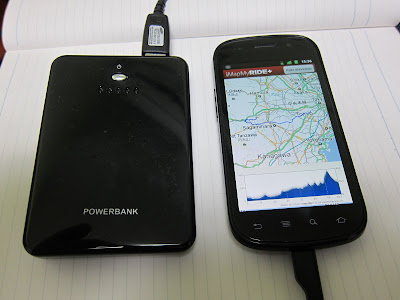
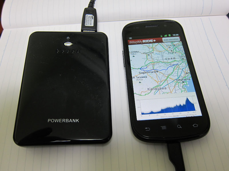
In order not to have to worry too much about that and to be able to record longer and further rides and hikes, I got myself a cheap external Li-ion battery on Amazon Japan, into which I can plug the USB cable of my Android phone for extra power. I paid JPY 2,380 (about $30) including shipping. Its capacity is listed as 5000 mAh and it has two USB output ports, plus one mini-USB input port for recharging. It comes with a USB cable for charging, a short spiral USB output cable and 10 adapters to connect it to different phone models (including the iPhone and iPod). Because of the standard USB ports you can use any existing USB cable that works with your phone. It’s like running your smartphone off power from your computer.

The device is about the weight and size of my phone. It came charged to about 60%. It should take a couple of hours to fully recharge it from empty.

If fully charged it should theoretically provide three complete charges for my mobile phone, which has a 1500 mAh battery inside, thereby quadrupling the length of rides I can record. Most likely, I will run out of energy long before my battery does 🙂

My longest distances with MapMyRIDE so far:

  • Bike ride: 71 km, 560 m elevation gain
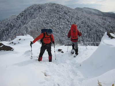
  • Mountain hike: 14 km, 1020 m elevation gain
  • Run: 10 km in Tokyo

A few rough edges

While the iMapMyRIDE+ app feels fairly solid, it will need fixes for a few problems.

The major issue for me is that the app and the website don’t see eye to eye on time zones. For example, if I record a ride at 17:00 (5pm) to 18:00 (6pm) on a Sunday, the recorded workout title will include the correct time. However, if I view that workout on the computer’s web browser, it is shown on the calendar as having been recorded on the following day (Monday). If I check the details, the start and end times are listed as 8am (08:00) and 9am (09:00): Wrong day and off by 9 hours.

Probably not by coincidence my time zone (Japan Standard Time) is 9 hours ahead of UTC. It’s like the app sends up the start and end time in UTC but the website thinks the data is local time. Yet for determining the date it seems to add those 9 hours again, which takes it beyond midnight and Sunday gets turned into Monday.

I can manually correct every single workout from the website, which also fixes that date on the calendar, but then the app displays the wrong time, which I am prepared to simply ignore.

When I enter my height on the website and then view my details on the app, I am 2 cm shorter than I entered, perhaps as the result of my height having been converted from metric to imperial and back to metric with numeric truncation.

I wish the site would support 24 hour clocks, not just AM/PM. I also wish the site would let the metric size to be entered as cm, not just m and cm separately (probably a hangover from code written for feet and inches).

Note to the app developers out there: The world is much bigger than the US and most of it is metric.

UPDATE 2011-12-13:

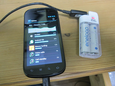
I have used the Li-ion battery on two weekend bike rides now. One was 93 km, the other 101 km in length. In both cases I first used the phone normally until the remaining charge level was heading towards 20% (after maybe 4 hours), then I hooked it up to the 5000 mAh battery and continued the ride. The longer of the two rides was about 8 hours, including lunch and other breaks. At the end of the 101 km ride the phone battery was back up to 75% charged, while the external battery was down to 1 of 5 LEDs, i.e. close to empty.

I wasn’t as careful to conserve power with the external battery hooked up. My phone is configured to not go into sleep mode while hooked up to a USB cable, unless I manually push the power button. That’s because I also use it for Android application development, where it’s controlled from a PC via the cable. I should really turn that developer mode off on rides to have the screen blank after a minute as usual even when getting external power. Total capacity with the external battery probably at least 10 or 11 hours, more if I put the phone into “airplane mode”, which disables map updates and hence navigation.

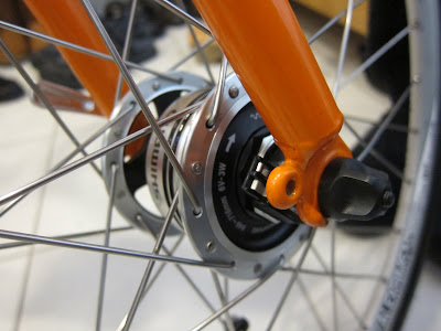
My headlight currently consists of a twin white LED light using a pair of CR2032 batteries that I need to replace every now and then. It’s not very bright, especially where there are no street lights. Probably next year I’ll upgrade the front wheel using a Shimano DH-3N72 dynamo hub,

which can provide up to 3W of power while adding very little drag. A 6V AC to USB adapter will allow me to power USB devices like my phone and the headlights from this without ever having to buy disposable batteries or connecting anything to a mains charger.

UPDATE 2012-01-02:

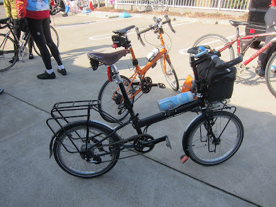
I have had the front wheel of my Bike Friday rebuilt with a Shimano DH-3N80 dynamo hub. The old 105 hub is now a spare while the rim with tube and tyre were reused. Here is the bike in our entrance hall:

Closeup view of the hub with AC power contacts:

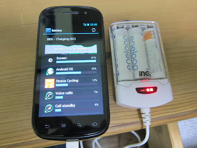
I purchased a USB power adapter made by Kuhn Elektronik GmbH in Germany. It weighs 40 g and measures 8 cm by 2.5 cm. It provides a standard USB-A socket which fits standard USB cables such as the one that came with my Google Nexus S:

USB power adapter with Google Nexus S:

UPDATE 2012-03-14:

At the end of January I started using Strava for tracking rides, in addition to MapMyRides (MMR). I stopped using the MMR app because there is no way in MMR to export GPX files with time stamps, so you can not track your speed or performance on any sites besides MMR. They lock in your data. Instead I either record with Strava on my Android 4 Nexus S or with Endomondo on my Android 1.6 Google Ion. That way I can generate GPX files that will upload to Strava, Endomondo, MapMyRide or just about any other site. The automatic competition feature of Strava is superb. MMR’s best features are its calendar view with weekly and monthly statistics and its mapping feature for planning rides. If those were merged with what Strava can do, it would be a terrific GPS cycling app and site.

Summit spam from Atlanta, Georgia

Recently I got a couple of spams sent to non-existent email addresses at a domain that I host. These spams were very similar, even though they use a variety of domain names and diferent postal address.

Here are some of the domains:

  • hr-summit.net
  • cfo-summit.net
  • cmo-summit.net
  • cmosummits.org
  • cmo-summit.org
  • bizsummits.org
  • thetrainingsummit.net
  • thecorporatecounselsummit.org
  • theengineeringsummit.com
  • theproductdevsummit.org
  • thepublicrelationssummit.net

Here are spam samples:

From: “J.R. Williams” <jason@hr-summit.net>
To: “XXXXXXXXXXXXXXX” <YYYYY@YYYYYYYYYYYYY>
Subject: Geoffrey, interesting speaker
Date: Tue, 4 Oct 2011 09:30:32 -0400

Hi Geoffrey, hope you are well. On Oct 12 at 12 pm ET I thought you would
enjoy dialing in to hear Welch’s VP of Human Resources speaking on
“Creative Ways of Developing Individuals in Smaller Organizations.” Just
go to our site to become part of our group (takes just a minute), thanks!

Truly yours,
J.R. Williams
HR-Summit
hr-summit.net

This message is confidential and intended only for the original recipient.
If you have received this message in error, please delete it or mail us
back if you no longer wish to receive further email. If any follow-up is
needed I show your contact information as XXXXXXXXXXXXXXX,
YYYYY@YYYYYYYYYYYYY ZZZZZZZZZZZZZZZZZ and you may also reach us
at 12OO Abernathy Road #1700, Atlanta Georgia 30328 or through the
contact information on our site.

Domain cfo-summit.net:

From: “Patrick Hansen” <patrick@cfo-summit.net>
To: “XXXXXXXXXXXXXXX” <YYYYY@YYYYYYYYYYYYY>
Subject: Karen, interesting speaker
Date: Thu, 13 Oct 2011 09:43:43 -0400

Hi Karen, hope you are well. On Nov 3 at 12 pm ET I thought you would
enjoy dialing in to hear Banner Health’s CFO speaking on “The Financial
Implications of the New Era of Healthcare.” Just go to our site to become
part of our group (takes just a minute), thanks!

Truly yours,
Patrick Hansen
CFO Summits
cfo-summit.net

This message is confidential and intended only for the original recipient.
If you have received this message in error, please delete it or mail us
back if you no longer wish to receive further email. If any follow-up is
needed I show your contact information as XXXXXXXXXXXXXXX,
YYYYY@YYYYYYYYYYYYY ZZZZZZZZZZZZZZZZZ and you may also reach us at
201 17th St, Ste 1200, Atlanta GA 30363 or through the contact
information on our site.

Domain thehrsummits.org:

From: “J.R. Williams” <jason@thehrsummits.org>
To: “XXXXXXXXXXXXXXX” <YYYYY@YYYYYYYYYYYYY>
Subject: Jack, interesting speaker
Date: Tue, 15 Nov 2011 12:25:12 -0500

Hi Jack, hope you are well. On Dec 7th at 12 pm ET I thought you would
enjoy dialing in to hear Four Seasons Hotel’s Director of Human Resources,
speaking on “Finding the Right People for the Right Job.” Just go to our
site to become part of our group (takes just a minute), thanks!

Yours Truly,
J.R. Williams
HRSummit
thehrsummits.org

This message is confidential and intended only for the original recipient.
If you have received this message in error, please delete it or mail us
back if you no longer wish to receive further email. If any follow-up is
needed I show your contact information as XXXXXXXXXXXXXXX,
YYYYY@YYYYYYYYYYYYY ZZZZZZZZZZZZZZZZZ and you may also reach us
at 201 17th St, Ste 1200, Atlanta GA 30363 or through the contact
information on our site.

Domain cmosummits.org:

From: “Matthew T. Keener” <matthew@cmosummits.org>
To: “XXXXXXXXXXXXXXX” <YYYYY@YYYYYYYYYYYYY>
Subject: Leo, interesting speaker
Date: Thu, 17 Nov 2011 10:55:06 -0500

Hi Leo, hope you are well. On Dec 5th at 12 pm ET I thought you would
enjoy dialing in to hear Aramark’s Associate Vice President of Marketing,
speaking on “Global Marketing.” Just go to our site to become part of our
group (takes just a minute), thanks!

Truly,
Matthew T. Keener
CMO-Summit
cmosummits.org

This message is confidential and intended only for the original recipient.
If you have received this message in error, please delete it or mail us
back if you no longer wish to receive further email. If any follow-up is
needed I show your contact information as XXXXXXXXXXXXXXX,
YYYYY@YYYYYYYYYYYYY ZZZZZZZZZZZZZZZZZ and you may also reach us
at 1200 Abernathy Rd, Atlanta Georgia 30328 or through the contact
information on our site.

Domains bizsummits.org / thetrainingsummit.net:

Reply-To: ryan@bizsummits.org
Date: Wed, 23 Nov 2011 00:35:37 +0000
Subject: John, follow up
From: Ryan English <trainingsummits1@gmail.com>

Hi John,

You recently expressed an interest regarding joining our Training Summit and on behalf of our Administration and Membership; it is my pleasure to extend an invitation to participate in upcoming events and to join our organization. The Training Summit is an invitation only group that is comprised of innovative leaders and visionaries in the Training and Learning & Development field. We discuss best practices and find ways to help one another. Here are some details on upcoming meetings along with the featured speaker that month:

12/01/11 Rob Patterson, CiTi, Senior Vice President, Learning Technology and Architecture-Topic: Utilizing Share points to support a learning organization

We meet once a month via teleconference. In between these monthly calls we have an online forum where our more than 200 members network and collaborate. The membership dues are $1,250 per year, there is a 30 day evaluation period, if you do not feel like the group is advantageous to you or a fit; you can request a full refund. A list of topics and upcoming speakers can be found at www.thetrainingsummit.net. Please contact me ASAP for registration as it is filling up quickly, as well as to confirm networking information. Thank you very much for your time and consideration, if you have any further questions please do not hesitate to call me at (330)-769-7628. I look forward to working with you, have a great day!

Regards,

Ryan English
Training Summit
Direct: 330-769-7628

This message is confidential and intended only for the original recipient. If you have received this message in error, please delete it or mail us back if you no longer wish to receive further email. You may also reach us at 1200 Abernathy Rd, Atlanta Georgia 30328 or through the contact information on our site.

Here are some more spam samples published on other websites, as I’m not the only one being spammed:

This company seems to have been at it for a couple of years already. They will probably keep going as long as some companies fall for their unsolicited emails and sign up.

Radiation maps for Eastern Japan

The Japanese government has released updated radiation maps for Eastern Japan from its helicopter survey. The maps now cover prefectures as far west as Gifu and as far north as Iwate and Akita. Previously there was map data only for Tokohoku (excluding Aomori) and the Kanto area. The PDF can be downloaded here.

The previous set of maps documented caesium contamination and background radiation levels in Fukushima, Tochigi, Miyagi, Ibaraki, Chiba, Saitama, Tokyo and Kanagawa. The latest set adds maps for Iwate, Shizuoka, Nagano, Yamanashi, Gifu and Toyama. Akita, Yamagata and Niigata have also been surveyed and are shown on the overview map.

The most heavily contaminated areas are in the eastern half of Fukushima prefecture, within about 80 km of the wrecked nuclear power stations. The southern part of Miyagi to the north and the northern part of Ibaraki to the south also took a hit.

A major radioactive plume moved south-west from Fukushima, polluting the northern half of Tochigi and the northern and western part of Gunma. A separate plume reached the southern part of Ibaraki, the north-west of Chiba and the eastern part of Tokyo.

There is also some caesium in the mountainous far west of Tokyo and Saitama that extended from Tochigi, but most of Saitama, Tokyo and Kanagawa seem relatively OK, as are Shizuoka, Yamanashi, Nagano, Gifu, Tokyama, Niigata, Yamagata and Akita. There is some fallout in a strip from southern Iwate to northern Miyagi, while central Miyagi and the rest of Iwate look clean. There is no published data for Aomori and Hokkaido yet, but based on the distance and the absence of significant pollution in Akita and adjacent parts of Iwate they will probably be fine.

The maps only give the overall picture, as there may be local hotspots in areas that are relatively clean overall, based on rainfall and wind patterns as well as soil and vegetation that can retain more or less fallout.

Update 2011-12-06:
The ministry has also published radiation maps for Aichi, Aomori, Ishikawa and Fukui prefecture.

Shimano PD-T780 SPD pedals and SH-MT42NV shoes

On Sunday I rode to Y’s Road in Shinjuku to buy clipless pedals and bike shoes. I did not want pure racing gear, but shoes I could also walk around in when I go shopping, as I usually take the bike for that. On my first touring bike in high school I used straps, but clipless pedals are supposed to be more efficient. With either you can maintain a higher cadence (pedalling speed), which optimizes power output compared to pedalling harder at slower pedal RPMs.

I chose PD-T780 SPD pedals and a pair of SH-MT42NV which are mountain bike shoes with recessed cleats. These pedals are part of Shimano’s Deore XT range and are meant for trekking. Because of that they have both a cleat side and a flat side, so you can also ride them with ordinary shoes, plus they’re equipped with reflectors. I like being as visible as possible in traffic, especially at night.

I found clipping in and out with SPD fairly straightforward, but there are some caveats. I’ve heard the warning that when you start using clipless pedals, you will crash at least once until you get the hang of it. It happens when you forget to unclip at least one shoe before coming to a complete stop. So far I’ve done 46 km without falling over, but I’ve been careful and started off with the loosest setting for the locking mechanism. If I find myself in a situation where I may have come to a stop (for example approaching a red traffic light or turning into a street where I might have stop to for traffic or if there are a lot of pedestrians about) I twist one foot to unclip but stay on the pedal so I can easily reconnect once it’s safe to do so, but also support myself if I suddenly need to stop. The other foot can always stay locked in.

If you’re more of a racing type of person, Shimano’s SPD-SL system may be a better choice, but for me SPD works just fine.

How (not) to decontaminate Japan

An article in Japan Times (2011-11-09, “Scrub homes, denude trees to wash cesium fears away”) provided advice on how to decontaminate areas affected by nuclear fallout, such as in Fukushima, Tochigi and northern Chiba prefecture. Most of the advice is sound, but some is downright alarming:

As for trees, it’s best to remove all their leaves because of the likelyhood they contain large amounts of cesium, Higaki [of University of Tokyo] said.
(…)
What should you do with the soil and leaves?
(…)
Leaves and weeds can be disposed of as burnable garbage, a Fukushima official said.

So let me get this right: you should collect all those leaves because they contain so much radioactive cesium (cesium 134 has a half life of 2 years and cesium 137 of 29 years). And then, when you have all that cesium in plastic garbage bags, you have it sent to the local garbage incinerator, so the carefully collected cesium gets spread over the whole neighbourhood again via the incinerator smokestack. That makes no sense at all.

Minoura iH-100-S phone holder for Nexus S

In my blog post about my bike ride up Mt Fuji Subaru line I mentioned the Minoura iH-100-S phone holder that I use with my Google Nexus S Android smartphone, which I use for Google Maps and the iMapMyRide application to track my cycling routes.

In the local bike shop I was was considering either the Minoura or the Topeak Phone Drybag, which is designed specifically for the iPhone, but also is big enough to hold the Nexus S. It offers rain protection, while with the Minoura iH-100-S the phone is exposed.

I didn’t go for the Topeak because it looked too iPhone-specific: The transparent cover extends to the home button in the bottom centre, but my Nexus S has four buttons side by side (Back, Menu, Search, Home), which would have been obscured.

My solution for rain is simple: If it looks rainy, I’ll wrap the phone in cellophane (for kitchen use, the local leading brand in Japan is Saran Wrap), which does the job. I also keep a small transparent plastic in my backpack, for emergencies.

The Minoura works well and grips the phone firmly if used properly. Make sure the phone firmly touches all three support points: the clamps on the left and right and the corner hook. I have yet to lose it, but the fact that the two clamps at the left and right snap apart if the release lever is pulled did make me a bit nervous. I always visualized this happening unintentionally, say if the release mechanism wears out or becomes brittle with UV exposure and breaks one day.

My peace of mind solution for that is a small rubber band which I keep attached to the holder. I twist it around once to give it more tension and then wrap it around the two clamps, which keep it away from the touchscreen, but it provides enough friction and tension that even when I pull the release lever there’s no way the phone would fly away.

Auto Unlock application

Another issue with using the phone for navigation was the Android screen lock. When the screen blanks due to inactivity, I need to push the power button to turn the screen back on, which is fine, but then I also need to slide a dot across the screen to unlock the desktop. If find that too distracting, because I prefer to keep my eyes on the road as much as possible. I found an application in the Android market called “Auto Unlock”, which does away with the need for the sliding move – most of the time. The trial version can be used for 5 days for free. The paid version is $1.29.

The results with Auto Unlock were a bit uneven. The application needs to be manually restarted after the phone is powered down, a minor problem. When it’s active, sometimes I still needed the slide, other times I didn’t. I’m not sure what made the difference. It’s very helpful as long as it works.

UPDATE (2011-10-15:

After the trial edition of “Auto Unlock” expired I switched to another app called “No Lock”. I am happy to say that No Lock works more reliably, though it has one minor drawback: unlike Auto Unlock it does not use the proximity sensor to still require an unlock swipe if it’s in your pocket. If you accidentally push the power button while the mobile is in your pocket, that may unlock it already. “Pocket-dialling” of calls is a possibility. For my use with the bicycle holder that is not a problem and it’s easy to switch between “No Lock” and “Lock” mode in the app.