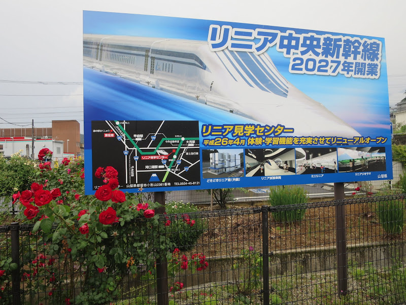
Not many cars drive on prefectural road 35 near Akiyama, but I’ve cycled there many times on the way to or from Tsuru city during brevets and other long rides. Akiyama’s claim to fame, other than being a charming rural backwater, is it’s Maglev test track, which will grow into a section of the 286 km Tokyo-Nagoya line scheduled to open 10 years from now in 2027.

The test track was built in the 1990s to develop and test prototypes for the train and track, first 18 km in length, then extended to 42 km to be able to test the train at higher speed. The best detailed summary about the route that I’ve found so far that is not in Japanese is this (in German).
Ten years is not a very long time for a project of this scale, especially when there is always the risk of unforeseen difficulties during tunneling (the known unknowns). A 25 km long tunnel will run between Hayakawa in Yamanashi and Oshika in Nagano. Construction has started at both ends. As the Maglev train needs a near level track, this will be a base tunnel at low elevation. Consequently there will be 1400 m of rock above at its deepest point.
Near the end points at Tokyo and Nagoya, new stations will be built under existing train stations (Shinagawa station in case of Tokyo). The lines will run in tunnels at least 40 m underground. Under Japanese law (“Deep Underground Law”), construction at least 40 m below the surface can be done without having to purchase the land above, as long as its purpose is deemed to be in the public interest.
The Chuo Maglev line has been called the world’s longest subway line, as more than 85% of it will be in tunnels. From Shinagawa the tunnel will first run southwest towards the Tamagawa, passing Senzokuike and crossing the river near Todoroki (between the Daisan Keihin and Tokyo Toyoko line bridges).
It continues on the Kanagawa side towards Sagamihara. Avoiding Machida to the south and Tama New Town to the north, it will run south of Onekansen. The first stop after Shinagawa will be near Hashimoto station, to connect it to the existing rail network (JR Yokohama line, JR Sagami line, Keiō Sagamihara line) with proximity to the Ken’ō Expressway. The Maglev line will cross the Sagami river on a bridge, heading between Tsukui-ko and Miyagase-ko.
A 50 ha railway yard for maintenance with train depot is planned near Toya, which my cycling friends mostly remember for the Sunkus convenience store north of Miyagase-ko. From there the line tunnels west through more mountains to the existing test track.
Altogether there will be 9 emergency exits that connect the line to the surface in the tunnel section near Tokyo.
If you check Google maps for the satellite view, you’ll see the test track line emerge to northwest of Tsuru. where it crosses national route 139 from Otsuki to Kawaguchiko. If you drive out from Tokyo on Chuo expressway, you can see the line cross over the expressway on a bridge. There’s a Yamanashi Prefectural Maglev Exhibition Center nearby.
Heading further west into Yamanashi, the line first stays a little south of Chuo mainline and the Chuo expressway, before those two swing northwest while the Maglev route heads straight west. You can see it emerge for shorts covered bridges near Hatsukari, then pop out for longer viaducts as it crosses national route 137 and prefectural route 36 on the edge of the big Yamanashi plain. The current end of the viaduct is at Fuefuki, Yamanashi, according to Google maps.
There will be a station for Yamanashi prefecture in Ōtsumachi near Kofu, with access to JR Minobu Line. [CORRECTION: Any transfer between Yamanashi station and any of the JR Minobu line stations will have to involve either buses or a yet to be built monorail, tram or other light rail infrastructure.]
The Yamanashi plain is where most of the above ground distance of the line will be found. The viaduct sections will either have noise barriers or complete covers. A main reason to opt for viaducts in this area is the relatively high water table, which would complicate tunneling.
The debris from 246.6 km of tunnel drilling amounts to 56.8 million m3 (some 145 million t by weight) that will be deposited at locations along the line.
Personally I’m a skeptic about this project. The time savings compared to regular bullet trains are relatively minor, once you factor in that most people will also spend a fair amount of time getting to and from one of the Maglev stations via conventional public transport.
For the people along the line who don’t live in Tokyo or Nagoya, they get one station per prefecture. Chances are, with Japan’s population on the decline, as the new line starts up that train services on the JR Chuo line, which runs somewhat parallel to the Chuo Shinkansen line, will get thinned out. We’ve seen the same thing with bullet train lines that opened that lead to cutbacks on other regional train connections.
So how much time will people actually save, if they don’t happen to live in Shinagawa and want to go to Nagoya or vice versa? Even Nagoya is only a halfway solution without the extension to Osaka that isn’t scheduled to be completed until 2045 (or 2037, if the central government steps in with a huge loan).
I think the only thing we can say with any certainty about benefits from the project is that, yes, the construction companies and the suppliers of equipment will benefit handsomely. Drilling and lining 247 km of tunnels with concrete and pouring some more of it for 24 km viaducts and 11 km of bridges will make them some money but will add a fair amount of CO2 to the atmosphere. The air resistance of trains at 505 km/h and therefore their energy consumption will definitely be higher than that of conventional trains. One source I saw listed it as having a CO2 output of 2-4x that of conventional commuter trains (not sure how those compare to a shinkansen).
Nevertheless, the dice have been cast and construction is under way. I will try and find more information about where construction is going on and what parts can be explored on bike rides or visited. You can already get train rides at the Maglev visitor center in Tsuru. There was some discussion of extending the test track 7 km to the west and building a station by 2020 to be able to offer test track rides as far as Kofu by the Olympics but without the Kanto connection that seems like a gimmick to me. I doubt that’s going to happen, as all kinds of construction projects are already competing for capacity before the magic Olympic year, driving up prices and busting budgets.
A journey starts with the first step ! Japan is already the most technologically advanced country. Chuo Shinkansen will only increase the gap between advanced Japan and backward US. As for the demographic decline of Japan maybe Japanese Americans will consider going back to Japan as they are already sick an tied of being called by Trump “inferiors” of “Asian race”.
In yamanashi I’ve read they are not even connecting to the minobu line. The track will cross the minobu line however the station will be several km east of it. They’re specifically avoiding a connection.
My guess is they want to kill the minobu line and so don’t want to breathe new life into it.
Craig, you’re right, the Yamanashi station is planned to be no closer than 3 km from the nearest Minobu line station and 8 km from JR Chuo line. It’s almost like JR never wanted to build a Chuo Shinkansen station in Yamanashi in the first place, but they were forced to have one for political reasons so they made it as isolated as possible so it gets as little use as possible (short stops?). It’s bizarre. The only people really benefiting from this line will be the people living near the two terminal stations and the huge construction companies who get to build the line.
You can see the exact location of the line via the following Google Maps link:
http://goo.gl/maps/AydSG
Track sections in red are underground (tunnels) while sections in blue are above ground (bridges and viaducts). Railway stations on the line are shown box shaped. The “human” icon indicates emergency exits. Houses with flags indicate power substations. Orange lines are roads for construction. Blue waves are storage sites for soil. Spanners indicate maintenance bases.